
NTSB accident ANC26FA091 is the crash of N9485P, a Piper PA-24-260 Comanche, into Seldovia Slough beside Seldovia Airport, Alaska, at 1:17 p.m. on August 26, 2026. All four people aboard died: the pilot, Eric Middlebrook, and his passengers Ronald Schmidt, Lance Schmidt and Daniel Simons.
This page is a reconstruction of that accident from the public record. Every figure names its source. Where the record has a gap, the gap is shown.
No probable cause exists. The NTSB has not said why this airplane crashed, and nothing on this page does either.
Interactive version: the annotated drawing of the accident sequence, with a satellite view of the site.
Who wrote this: I am Ilana-Ruth Bevan. Eric Middlebrook was my uncle. I am not a pilot and I am not a neutral party. This page is the factual record.
Last updated October 1, 2026. The NTSB’s public docket had not been released when last checked on October 1, 2026.
On this page
- What happened in the Seldovia plane crash
- What the NTSB preliminary report for ANC26FA091 says
- Seldovia Airport: the runway, the trees and the wind
- Where N9485P came to rest: the geometry
- What is a go-around?
- What is not known about ANC26FA091
- Who was aboard N9485P
- How long does an NTSB final report take?
- Interactive reconstruction of ANC26FA091
- Sources
- Corrections and updates
What happened in the Seldovia plane crash
- A four-seat, single-engine airplane flew from Merrill Field in Anchorage to Seldovia, a small town on Kachemak Bay with one short gravel runway.
- It came in to land heading south. A witness said it appeared to be coming in fast.
- It bounced three times on the runway. The bounces sounded hard and abnormal.
- The engine went to full power and the nose pitched up steeply. That is the start of a go-around: climbing away to circle back and land again.
- Just past the end of the runway the airplane was unusually low. It hit a tree and came down in Seldovia Slough, a tidal channel beside the airport.
- The airplane sank. The four men were recovered at about 6:30 p.m., after the tide went out.
That is the sequence as witnesses described it to the NTSB. Why it happened has not been determined.
What the NTSB preliminary report for ANC26FA091 says
The NTSB released its preliminary report on September 16, 2026. The primary document is here: web.ntsb.gov/investigations/?ntsbnumber=ANC26FA091. The investigator in charge is Mark Ward. This is the whole of its narrative:
“The pilot and three passengers departed from Merrill Field Airport (PAMR), Anchorage, Alaska, for a day flight to Seldovia Airport (PASO), Seldovia, Alaska. A witness at the Seldovia airport heard the airplane approaching to land on runway 16 and the airplane appeared to be coming in fast. He then heard a series of bounces which sounded hard and abnormal. The first bounce was loud and not a normal touchdown sound. He heard a second bounce which also sounded hard and abnormal. He visually saw the third bounce and believed that the nosewheel hit the ground first. He then heard the engine go to full throttle. He stated that the aircraft pitched up very high and possibly had a tail strike. A witness working with heavy equipment near the end of the runway saw the airplane and noted the airplane was unusually low to the ground just past the end of the runway. He further noted that the accident airplane had attempted to land in the opposite direction of other airplanes that had been landing. Multiple ground witnesses reported seeing the airplane unusually low to the ground, the engine being very loud, and the airplane impacting a tree before descending into the water.”
“The airplane came to rest about 2,200 ft from the end of runway 16 into the Seldovia Slough. A detailed wreckage examination is pending.”
Other facts from the same report [NTSB]:
- Date and time: August 26, 2026, 1:17 p.m. Alaska daylight time.
- Aircraft: Piper PA-24-260, registration N9485P. Damage: substantial. No fire.
- Injuries: four fatal, one pilot and three passengers.
- Type of flight: personal, under Part 91. No flight plan was filed.
- Resting point: 59.434666, -151.711210.
- Parties to the investigation: Piper Aircraft and the FAA. Lycoming, the engine manufacturer, is also assisting [PRESS, Homer Independent Press, September 3, 2026].
The preliminary report contains no probable cause. That is by design: it records what was collected in the first weeks.
How to read the labels on this page
Each event carries one of five labels that say how well it is known:
- MEASURED: a coordinate, a chart figure or an instrument reading.
- SEEN: a witness watched it happen. Seen does not mean located.
- HEARD ONLY: a witness heard it and nobody saw it.
- REPORTED: relayed by someone other than the person who saw it, and not in the NTSB’s account.
- UNKNOWN: not in any public source.
Each number carries a tag for where it came from:
- [NTSB]: stated in the preliminary report.
- [FAA]: the FAA’s airport record for Seldovia.
- [NOAA]: NOAA tide station 9455500, Seldovia.
- [METAR]: the airport weather station’s transmitted observations.
- [ADS-B]: aircraft position broadcasts archived by adsb.lol.
- [PRESS]: a named news outlet.
- [VIDEO]: published news or witness video.
- [AUDIO]: LiveATC’s archived recording of the Merrill Field ground frequency.
- [TYPE]: true of the PA-24-260 in general, not verified for this airplane.
- [CALC]: calculated here, with the inputs shown.
The sequence, event by event
The NTSB gives one time, 1:17 p.m., for the whole sequence. No public source gives a time for any single event. The order is known. The spacing is not.
| # | Event, in the NTSB’s words | How it is known | Position |
|---|---|---|---|
| 1 | Approach to runway 16, “appeared to be coming in fast” | HEARD ONLY, witness at the airport | None recorded |
| 2 | First bounce, “loud and not a normal touchdown sound” | HEARD ONLY | Somewhere on the runway |
| 3 | Second bounce, “hard and abnormal” | HEARD ONLY | Somewhere on the runway |
| 4 | Third bounce. The witness “believed that the nosewheel hit the ground first” | SEEN | Somewhere on the runway |
| 5 | Engine to full throttle | HEARD ONLY | None recorded |
| 6 | Airplane “pitched up very high and possibly had a tail strike” | SEEN | None recorded |
| 7 | “Unusually low to the ground just past the end of the runway” | SEEN, witness on heavy equipment near the runway end | The only position a witness gave. No height. |
| 8 | “Impacting a tree” | SEEN, multiple ground witnesses | Which tree is not established |
| 9 | “Descending into the water” | SEEN, multiple ground witnesses | No entry point measured |
| 10 | Came to rest in Seldovia Slough | MEASURED | 59.434666, -151.711210 |
“Believed” and “possibly” are the witness’s own hedges. Whether the nosewheel hit first, and whether the tail struck the runway, are not established.
What the Merrill Field recording adds
LiveATC, which archives air traffic control radio, supplied its recording of the Merrill Field ground frequency for that afternoon at my request. N9485P is on it [AUDIO].
- About 12:12 p.m.: the pilot asks Merrill Ground for taxi from his parking area, says he has the airport’s current weather broadcast, and says he is southbound. Ground clears him to taxi to runway 26.
- How the time is known: the recording has no clock. Three other aircraft on it also appear in ADS-B data, and matching them puts the start of the recording at 12:00 noon Alaska time to within about a minute [ADS-B, CALC].
- What it shows: the airplane had a working radio at Merrill and the pilot used it, about 65 minutes before the accident.
- What it does not show: the takeoff. That would be on the tower frequency, and LiveATC’s tower recordings for that half hour are too damaged to read. The takeoff time is UNKNOWN. Other aircraft that day took about 3.5 to 6 minutes from taxi call to takeoff, which would put it at roughly 12:15 to 12:19 p.m. [CALC, an estimate].
It says nothing about Seldovia. No recording of the arrival exists.
What the witness video adds
Alaska’s News Source published phone footage taken at the scene that afternoon, credited to Lindsey Burnett (the outlet also spells it Lindsay). Two things in it are in no NTSB document and in none of the written articles I archived [VIDEO].
- A wing dropped. REPORTED. She says her father saw one of the airplane’s wings go down just before the crash, and she tilts her hand to show it. She is relaying what he saw. Which wing, and whether it was before or after the tree, are UNKNOWN. A second clip of her saying her father saw it tip is the same observation told again, not a second witness.
- Someone may have filmed the airplane in flight. REPORTED. She says people nearby got video of the airplane climbing out and hitting a tree, and the camera turns to a group of bystanders as she says it. No such video has been published. The NTSB has asked anyone with video to write to witness@ntsb.gov [PRESS].
Most of the REPORTED material about this accident comes from one family’s phone, re-cut by several outlets. Seeing it in three places is not three witnesses.
What the recovery footage shows
The wreckage was lifted out of the slough by helicopter on August 27, 2026, and taken to Anchorage for examination [PRESS, VIDEO]. Three videos show the lift. I went through 4,164 frames of them [VIDEO].
- Crushed from the nose back to the windshield. The engine and nose are folded down and aside, and the front of the cabin, where the windshield and instrument panel were, is torn open.
- The cabin shell behind that holds its shape. The window frames, the roofline and the side of the fuselage back to the registration number are intact.
- The tail is bent and still attached. Early press descriptions said it was broken off. The footage does not show that.
- All three landing gear legs are extended.
- One wing is close to full span and the other is crumpled.
- The wreck was lying upside down or heavily rolled on the tidal flat before the lift.
A recovery video shows the end state. Between the crash and the lift the airplane sat through a full tide cycle with people working on it. Wheels down in the wreck does not establish wheels down at impact. Upside down at recovery does not establish upside down at water entry. The damage is that of a nose-first impact, and whether that was with the trees or with the water is not established.
Seldovia Airport: the runway, the trees and the wind
One runway, two names
Seldovia Airport (PASO) has a single gravel runway, 1,845 feet long [NTSB] and 80 feet wide [FAA], at 29 feet above sea level [NTSB]. Landing toward the south it is called runway 16. Landing toward the north it is called runway 34. It is the same strip. Pilots normally land into the wind.
- The airport has no control tower. Pilots announce themselves on a shared frequency, 122.9 [FAA], which nobody records. No recording of radio calls from this approach exists.
- An automated weather station on the field broadcasts on 135.4 [FAA]. Whether the pilot listened to it is UNKNOWN.
- The FAA’s airport record carries a standing remark, “EXP WIND SHEAR ON APCH”: expect wind shear on the approach [FAA]. It does not establish that wind shear occurred that day.
The trees and the 11 to 1 slope
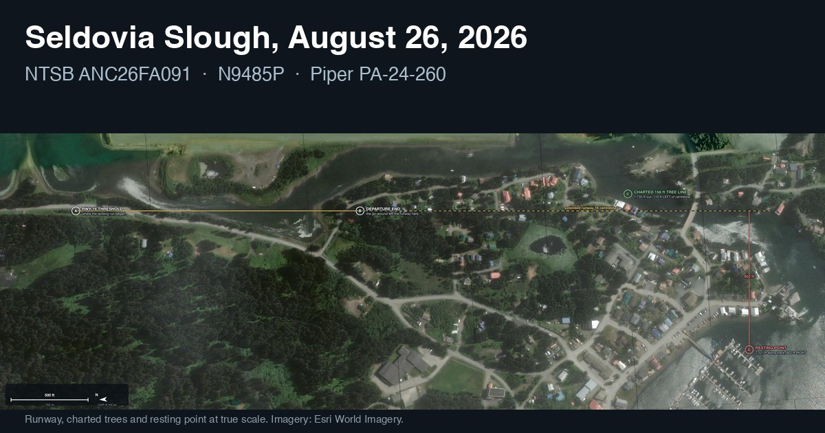
- Off the end of runway 16: trees 158 feet tall, 1,735 feet from the runway, 110 feet left of its centerline [NTSB].
- Slope needed to clear them: 11 to 1, meaning one foot up for every 11 feet forward [NTSB].
- Off the other end, on the approach the airplane flew: an 89 foot tree, 995 feet from the runway [NTSB]. It is not part of the accident sequence.
Which tree the airplane struck is not established. The written report says “a tree” [NTSB]. The NTSB’s Alaska region chief, Clint Johnson, was quoted on September 3, 2026: “The airplane did strike trees at the end of the runway” [PRESS, Homer Independent Press]. A September 17 broadcast also says several trees [VIDEO, Alaska’s News Source]. How many, which ones, and at what height are UNKNOWN.
The wind on August 26, 2026
The wind favored runway 34. The airplane landed on runway 16, with the wind behind it.
- 1:15 p.m., two minutes before the accident: from 020 degrees at 5 knots, gusting to 9. Clear sky, visibility 10 miles, 13°C [NTSB].
- 12:53 a.m. to 12:07 p.m.: calm, or light and variable at 3 knots, for twelve hours [METAR]. With no wind, either direction serves.
- 12:53 p.m.: the first observation with a northerly wind, 010 degrees at 5 knots [METAR]. That is 24 minutes before the accident.
- The evening before: a southerly wind of 4 to 9 knots, which favored runway 16 [METAR].
Five knots is a light wind. A tailwind raises the airplane’s speed over the ground at touchdown, which fits “coming in fast” and lengthens the landing on a short runway.
One open item: the gust of 9 knots in the NTSB report does not appear in any of the 30 observations the station transmitted that day, and none was transmitted between 12:53 p.m. and 1:46 p.m. [METAR]. The likely source is the station’s one-minute data, which is not public. I am noting the difference, not disputing the NTSB.
The air was cool and near sea level: density altitude about minus 344 feet [CALC, from the NTSB’s temperature and pressure]. The engine and wings had full performance available. Thin air does not explain a failure to climb here.
Which way other aircraft landed that day
The NTSB’s witness said the airplane landed “in the opposite direction of other airplanes that had been landing” [NTSB]. Past tense. The report does not say other aircraft were in the air at the same time.
| Time [ADS-B] | Movement | Direction |
|---|---|---|
| About 11:38 a.m. | Arrival, aircraft not identifiable | Runway 34, northbound |
| About 11:40 a.m. | Arrival, N100NS | Runway 16, southbound |
| About 12:41 p.m. | Arrival, N9957M, a Cessna 207A | Runway 34, northbound |
| About 1:02 p.m. | Departure, N9957M | Runway 34, northbound |
- The last two movements before the accident, 36 and 15 minutes earlier, both used runway 34. That supports the NTSB witness from an independent source.
- In the calm of the late morning, aircraft used both directions two minutes apart. Runway 16 was not an unusual choice that morning. The wind arrived afterward.
- No aircraft appears at the field between 1:04:50 and 1:24:30 p.m. That is a gap in the record. Aircraft without ADS-B equipment do not appear in it, and N9485P does not appear in it on any date I checked.
How deep was the water in Seldovia Slough?
Reported depths over the wreck range from 13 to 17 feet [PRESS]. The figures in circulation:
- 13 to 14 feet [PRESS, Alaska’s News Source].
- About 15 feet [PRESS, from the Alaska State Troopers’ dispatch of August 26].
- 16 to 17 feet [PRESS, Alaska Public Media].
The tide explains the spread. The tide station about 1.2 kilometers from the wreck read about 13.6 feet at 1:17 p.m. and rose to a 17.0 foot high at 2:55 p.m. [NOAA]. By 6:30 p.m., when the men were recovered, it had fallen 6.5 feet from its 1:17 level [NOAA, CALC].
A tide gauge reading is a water level, not the depth over the wreck, which also depends on the bottom. No single depth figure is supportable, so the range stands.
Where N9485P came to rest: the geometry
All of this is arithmetic on published coordinates, shown so it can be checked.
The inputs
- Resting point: 59.434666, -151.711210 [NTSB].
- The two ends of the runway: from the FAA airport record [FAA]. As a check, the distance between them comes out to 1,841 feet, against the published 1,845 [CALC].
- Direction of runway 16: 184.1 degrees true, very nearly due south [CALC from the FAA runway ends]. Subtract the local magnetic variation of 23 degrees east [FAA] and you get 161, which rounds to the “16” painted on the runway.
The slope and the trees are the same number
- 1,735 feet ÷ 11 = 157.7 feet. The charted trees are 158 feet [NTSB, CALC].
- 158 ÷ 1,735 = 9.1 percent. That is the climb gradient the published slope asks for [CALC].
- The published slope has no margin built into it.
Climb rate needed to reach 158 feet in 1,735 feet, by speed over the ground [CALC]:
| Groundspeed | Time to the trees | Climb rate needed |
|---|---|---|
| 60 knots | 17.1 seconds | 553 feet per minute |
| 70 knots | 14.7 seconds | 646 feet per minute |
| 80 knots | 12.8 seconds | 738 feet per minute |
| 90 knots | 11.4 seconds | 830 feet per minute |
| 100 knots | 10.3 seconds | 922 feet per minute |
A PA-24-260 is generally credited with about 1,300 to 1,500 feet per minute at full weight, with wheels and flaps up, from an established climb [TYPE]. A climb started from a bounced landing, at low speed, with wheels and flaps likely still down, is a much harder case. This airplane’s actual speed, weight and configuration are UNKNOWN.
The wind component
- Wind from 020 degrees, runway pointing 184.1 degrees: the wind is 164.1 degrees off the nose, almost directly behind [CALC].
- Tailwind = wind speed × cosine of 15.9 degrees. At 5 knots, 4.8 knots of tailwind. At the 9 knot gust, 8.7 knots [CALC].
- Crosswind = wind speed × sine of 15.9 degrees. 1.4 knots steady, 2.5 knots in the gust [CALC].
The resting point is not on the runway’s line
- NTSB text: “about 2,200 ft from the end of runway 16” [NTSB]. A distance, with no direction given.
- From the NTSB’s coordinate: 2,678 feet in a straight line from the end of the runway [CALC].
- Split into two parts: 2,521 feet along the runway’s extended centerline, and 902 feet to the right (west) of it [CALC]. Check: 2,521² + 902² = 2,678².
The 2,200 feet in the text and the 2,521 feet computed from the NTSB’s own coordinate differ by 321 feet. I have not reconciled them and I am not choosing between them.
An airplane that kept flying straight off the end of the runway would not be 902 feet to the side. At some point it moved well to the right.
The charted trees are 110 feet left of the centerline and the wreck is 902 feet right of it. So either the tree that was struck was not one of the charted ones, or the airplane crossed the centerline after the strike. If it was the charted trees: 2,521 minus 1,735 leaves 786 feet forward, 902 plus 110 is 1,012 feet sideways, which is 1,282 feet in a straight line on a track about 52 degrees off the runway’s direction [CALC]. That is conditional on which tree, which is UNKNOWN.
What is a go-around?
A go-around is an abandoned landing. The pilot adds full power, climbs away, and circles back to try again. It is a normal, trained maneuver.
The NTSB report does not use the word. It describes the engine going to full throttle after the third bounce and the nose pitching up [NTSB]. Clint Johnson, identified in press coverage as the NTSB’s Alaska region chief, described it on camera as a possible attempted go-around and said the agency was not drawing conclusions [VIDEO].
Why this one was demanding, from the facts above:
- It started from the ground. A go-around begun in the air starts with flying speed. One begun after three bounces starts with whatever speed is left. How much was left is UNKNOWN.
- The runway is 1,845 feet. Three bounces used an unrecorded amount of it [NTSB].
- The wind was behind the airplane, by 4.8 to 8.7 knots [CALC]. An airplane needs speed through the air to climb, and with a tailwind it covers more ground getting there.
- The nose was very high. At low speed a steep nose-up attitude adds drag and reduces climb [NTSB for the attitude].
- The trees ahead need a 9.1 percent climb with no margin [NTSB, CALC].
None of that says why the airplane did not climb. The same facts fit a healthy airplane short of speed and an airplane with something wrong with it.
Bystanders in the witness video describe hearing what sounded to them like a takeoff, and then the crash [VIDEO]. An early FAA database entry listed the accident as a takeoff. The NTSB’s account, an aborted landing, is the authoritative one.
What is not known about ANC26FA091
This is most of the accident. The preliminary report is a set of witness accounts, one coordinate and a weather observation. Nearly everything that would explain the crash is physical evidence in the wreckage, which the NTSB holds and has not yet published.
| UNKNOWN | Why, and what would settle it |
|---|---|
| The cause | No probable cause exists. It comes with the final report. |
| Whether the engine was making full power | The marks on the propeller blades are the most direct evidence. Wreckage examination pending [NTSB]. |
| Whether the flight controls were intact and connected | Wreckage examination. |
| Position of the pitch trim, flaps and landing gear at impact | Wreckage examination. The wheels are down in the recovery footage, which shows the wreck and not the moment of impact. |
| Airspeed, height and flight path at every point | No radar or ADS-B track of N9485P turned up in the public archives I searched, on the accident day or on any date sampled across the year before it. No flight plan was filed [NTSB]. |
| Weight and loading | Not published. |
| Fuel quantity and condition | Not published. |
| Which trees were struck, how many, at what height | The record says both “a tree” and “trees.” |
| Which wing dropped, and when | One second-hand account. An in-flight video, if it exists, would show it. |
| Whether the tail struck the runway | The witness said “possibly” [NTSB]. |
| Whether the pilot had the current wind, and whether he made radio calls | The frequency is not recorded. Witness statements in the docket may speak to it. |
| Whether any bystander reached the airplane | People went into the water within minutes [PRESS, VIDEO]. No source says what they reached. Troopers could not reach the wreckage until the tide went out [PRESS]. |
| Where each person was seated, and seat belt use | Not published. The type has one cabin door, on the right side by the front passenger seat [TYPE]. |
| Cause of death for each person | Autopsy results go to next of kin and are not published. |
| The takeoff time from Merrill Field | The taxi request is on the ground recording at about 12:12 p.m. [AUDIO]. The takeoff itself is on tower recordings that are too damaged to read. |
| The airplane’s year of manufacture, total hours and maintenance history | Not published. |
The explanations that remain open
None of these is established, and the NTSB has not ranked them.
- The airplane could not climb fast enough, with a healthy engine. Bearing on it: a tailwind, a short gravel runway, four adults aboard, a fast approach, three bounces, a steep nose-up attitude at low speed, and a 9.1 percent climb needed. Missing: the actual weight, speed and configuration.
- The engine was not making full power. Bearing on it: the airplane did not clear trees this type can normally clear in cool sea-level air [TYPE]. A September 17 broadcast relays witnesses describing the engine as sounding like it was struggling, and the official relaying it said he could not judge that himself [VIDEO]. Against: witnesses heard the throttle go forward and described the engine as very loud [NTSB]. A partial loss of power can still be loud.
- The pilot was incapacitated. Nothing in the public record supports or excludes it. The sequence includes a flown approach, three bounces, a throttle change and a pitch-up, so it would have to fall in the last few seconds.
- Something other than the engine failed. Nothing in the public record supports or excludes it.
Who was aboard N9485P
- Eric Middlebrook, 68, of Anchorage, the pilot and the registered owner of the airplane. He was a former mayor and city council member of Bethel, Alaska.
- Ronald Schmidt, 65, of California.
- Lance Schmidt, 20, of California.
- Daniel Simons, 82, of California.
Names, ages and residences: Alaska State Troopers [PRESS, Anchorage Daily News, August 27, 2026].
A correction to the press record: news reports, following the Associated Press, describe Eric Middlebrook and Ronald Schmidt as brothers. They were step-brothers.
How long does an NTSB final report take?
The NTSB says it generally tries to complete an investigation within 12 to 24 months. For ANC26FA091 that points to a final report, with a probable cause, between about August 2027 and August 2028.
Before the final report, the NTSB opens a public docket: the wreckage examination, witness statements, photographs and other factual material. The docket for ANC26FA091 will appear at data.ntsb.gov/Docket?NTSBNumber=ANC26FA091. As of October 1, 2026 it had not been released. I check it monthly and will update this page, at this address, when it opens and again when the final report is published.
Timeline
| When | What |
|---|---|
| August 26, 2026, about 12:12 p.m. | N9485P requests taxi at Merrill Field, Anchorage [AUDIO] |
| 12:53 p.m. | First northerly wind observation at Seldovia after twelve hours of calm [METAR] |
| 1:15 p.m. | Weather observation cited by the NTSB [NTSB] |
| 1:17 p.m. | The accident. The only time given for the whole sequence [NTSB] |
| 1:18 p.m. | Troopers notified [PRESS] |
| 2:55 p.m. | High tide, 17.0 feet [NOAA] |
| About 6:30 p.m. | The four men recovered after the tide went out [PRESS] |
| August 27, 2026 | Wreckage lifted by helicopter and taken to Anchorage [PRESS, VIDEO] |
| September 16, 2026 | NTSB preliminary report released [NTSB] |
| Not yet | Public docket |
| About August 2027 to August 2028 | Final report with probable cause, on the NTSB’s general timing |
Interactive reconstruction of ANC26FA091
Open the interactive reconstruction. It is one large annotated drawing you can pan and zoom:
- A side view of the runway, the 11 to 1 slope, the trees and the water, with all ten events placed according to how well each is known.
- A view from above showing the 902 foot offset.
- The wing drop and the witness video.
- The wind and the other traffic that day.
- The full list of unknowns.
- A second tab with the same points on a satellite photograph.
Everything in it is also on this page in text.
Sources
- NTSB Aviation Investigation Preliminary Report, ANC26FA091: web.ntsb.gov/investigations/?ntsbnumber=ANC26FA091
- NTSB, The Investigative Process (for the 12 to 24 month figure): ntsb.gov/investigations/process
- Alaska Department of Public Safety dispatch AK26084375, August 26, 2026: dailydispatch.dps.alaska.gov
- FAA airport record for Seldovia (PASO), read September 30, 2026.
- NOAA tide station 9455500, Seldovia, observations for August 26, 2026.
- Seldovia (PASO) weather observations for August 26, 2026, all 30 transmitted reports.
- adsb.lol open archive of aircraft position data for August 26, 2026.
- LiveATC.net archive recording, Merrill Field (PAMR) Ground, August 26, 2026, 2000Z, supplied on request October 1, 2026.
- Anchorage Daily News, August 27, 2026: Troopers identify 4 killed in plane crash into water near Seldovia’s airport
- Anchorage Daily News, September 18, 2026: NTSB: Fatal Seldovia plane crash occurred during second attempt after hard landing
- Homer Independent Press, September 3, 2026: Plane in fatal Seldovia crash struck trees in aborted landing
- Alaska’s News Source, August 26, 2026: first report
- Alaska’s News Source, August 28, 2026: witness footage and helicopter lift of the wreckage
- Alaska’s News Source, September 16, 2026: New details released by investigators, and its broadcast of September 17, 2026.
- The Alaska Story, September 16, 2026: NTSB preliminary report released
- FLYING Magazine, September 17, 2026: NTSB PA-24 Alaska crash preliminary report
- Aviation Safety Network: wikibase entry 579163
Corrections and updates
- October 1, 2026: first published. No probable cause exists. Docket not yet released.
- October 1, 2026: added the Merrill Field ground recording: the pilot’s taxi request at about 12:12 p.m.
If you saw the accident, have video of it, or can correct anything here, the NTSB’s address for witnesses is witness@ntsb.gov.

